AT FIRST GLANCE it might not strike you, but many
Dutch people live in the midst of a treacherous landscape. The story of
the Dutch reclaiming their country from the sea is a familiar tale, but
the fact that they are now well on their way to returning the land to
that very same sea is something new, even for the majority of Dutch people.
The increase in flooding because of climate change is, of course, the
outcome of human behaviour, but that is not what I mean; in general, the
dikes here still fulfil their protective task. The danger lies in the
land behind the dikes, the polders, which are subsiding ever further because
of urbanization and highly effective water management systems. Architecture
and urban development are increasingly capitalizing on this, by coincidence
but also intentionally.
Until the 1960s, the dynamism of water was a natural fact. When building
a house in an area that might be flooded you laid flagstones in your living
room instead of a parquet floor. If the water rose then you moved the
furniture to the first floor and went to lodge with family elsewhere.
Once the water level had fallen you scrubbed the floors and put the furniture
back in its place. Since the 1960s, the faith in our technical ability
to control water has been growing, and as a result we have become less
and less concerned about the sites used for construction. The state secretary
still actually considers it a ‘tremendous challenge’ to build
at the lowest point in the Netherlands, which is about six metres below
sea level. It is our heart’s desire to live overlooking water, and
to achieve this we are all too happy to re-excavate previously filled-in
urban canals. The water is an enemy that has become a friend, and our
understanding of the true dynamism of water and its perceived image have
become increasingly estranged.
Thanks to our engineering acuity it was possible to construct part of
the Randstad urban conurbation on the waterlogged soil of a former morass.
Houses are built on piles that sometimes have to be driven to a depth
of thirty metres in order to reach the solidity of the sand layer beneath
the peat, a substratum that will no longer subside. However, that is prohibitively
expensive for roadways, footpaths, parks and gardens, which are subsequently
lain on a layer of sand that is a ‘mere’ metre or two deep.
A layer like this stabilizes the unstable topsoil a little and, at least
on completion, looks very trustworthy. However, this semblance of stability
leads to absurd situations. Any weight that rests on the unstable soil
compresses it, and pumping off water, made necessary by the situation
below sea level, lends a helping hand. With every new layer of sand that
is added to keep houses accessible the ground subsides even faster. It
is a process that is unstoppable. In the city of Gouda, midway halfway
between Utrecht and Rotterdam, there are roads that people suspect are
now between 8 and 12 metres thick. Layer upon layer of asphalt has been
added on top of the roads that are sinking into the peat in order to maintain
them at surface level and to make them appear stable. This fixation on
the superficial pretence of stability typifies many of today’s trends
in spatial planning and water management
In many new residential districts, the soggy ground is hardly even taken
into account. The engineers simply spray on a two-metre layer of sand
in order to stabilize the watery and unstable subsoil, whereupon construction
can begin. By a circuitous route, that water has recently started to find
its way back to the surface. In order to gain the confidence of the homebuyer,
developers make every effort to imbue the new residential areas with individuality,
authenticity and identity. Oddly enough, this identity is not sought in
the landscape in the midst of which the property is being built –
in any case, that landscape has been completely eradicated by the addition
of a layer of sand – but is usually conceived afterwards. After
all the problems of development, land parcellation, infrastructure and
water management have been solved, it is time to consider identity. Then
the landscape-related elements or the location’s original qualities
can be reintroduced, but in a manageable and symbolic manner. And ‘water’
is then seized upon enthusiastically at places where it in fact plays
a much more essential role, as at the VINEX development site of Carnisselanden
near Barendrecht, just south of Rotterdam. The ‘soundings’
to determine the soil quality here were not quite sufficiently detailed
to gain a true impression of the former marshland. The geological survey
therefore confused the traces of an old creek with a thick layer of peat.
And as a result of the creek’s layer of ‘thick water’,
the sewers that were installed on Friday had already sunk to an undetectable
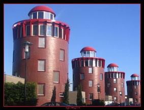
depth by Monday. Later on, at the same site as the ‘disappearing’
sewers, a series of ‘lighthouse dwellings’ was realized, giving
the spot a readily marketable identity and reflecting the connection with
water. This relationship was initially left unacknowledged, then combatted,
and ultimately represented in a ridiculous way.
This example demonstrates that in the quest for identity its most important
vectors are often missed. These ‘bearers’ of identity have
for a very long time been the specific limitations of a site within which
a particular development ambition has to be conceived and realized. For
centuries, limitations were the most effective shapers of our ambitions
and therefore prescribed our built identity. Nowadays we resolve the limitations
using technical means and contrive an identity afterwards. To this end,
it is often the icons that have evolved over time that are copied, such
as lighthouse dwellings, typical dike and bridge houses or windmills,
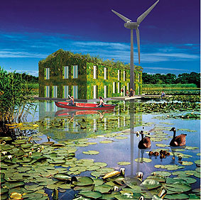
but we fail to develop new icons. Proceeding from this idea, I devised
the ‘Amphibious Living’ project in 2000, a project that generated
many potential new icons for settlement and for water.
No more than a decade ago, you could receive a premium from Gouda City
Council if you abandoned your houseboat and allowed it to be demolished.
Houseboats were then still subject to the municipality’s legislation
on slum dwellings. Even a city like Amsterdam has never been truly happy
with the houseboats lining its canals. They certainly provide picturesque
photo opportunities, but they are an untidy eyesore amid the cityscape,
they constitute a safety risk and they discharge sewage directly into
the canal. Houseboats were legally considered to be moveable property
and were therefore ineligible for a mortgage or for rent subsidy. It was
usually DIY adventurers who made their home on the water. However, this
policy shifted about five years ago. Alongside increasing prosperity and
liberalization of the housing market this was primarily driven by the
abovementioned quest for identity in the built environment. Living alongside
water had been a guaranteed sales hit for a long time already, but living
on water was now deemed worthy of a mortgage as well.
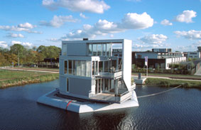
In more and more expansion plans, plots are being reserved for floating
dwellings in developments with overblown names such as ‘Water Gardens’,
‘Blue City’ or ‘Gold Coast’. The lakes and canals
in these newly built neighbourhoods are also mockingly called ‘estate
agent’s water’. Thanks to the introduction of tailor-made
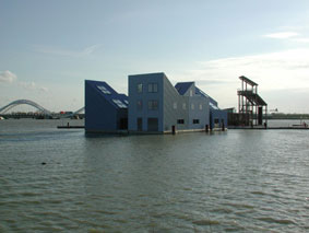
mortgages and to a number of ‘water villas’ being realized
by respected architects such as Herman Hertzberger and Art Zaaijer, living
on water has transcended the world of adventurers and odd-jobbers and
has become socially desirable. This goes hand in hand with the image of
freedom and independence that is associated with living on water. The
floating dwellings can be turned to face the sun or even moved to a completely
different location. The reality is different, of course, because the plots
are usually so confined that there is not much chance of being able to
turn, and the dwellings are generally fitted with every modern convenience
and are therefore wholly dependent on the umbilical cord of mains and
amenities at their moorings. These mooring places are limited in number,
so the dwelling cannot be tied up anywhere, to say nothing of the often
insurmountable obstacles such as bridges and dikes that the dwelling would
encounter en route from one berth to another. The freedom and independence
of the marketing brochures therefore rely on suggestion, but that is precisely
the level at which they work best. The inhabitants of floating dwellings
are generally very fond of their comfort and security. They are primarily
seeking the image of independence and the sense of freedom without having
to suffer the negative consequences.
For the housing market, the quest to distinctively combine human settlement
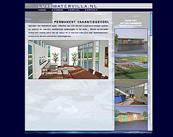
and water has become a welcome and rewarding theme. Architecture bureaus
with names such as Aquatecture and Waterstudio are capitalizing on this
trend and present their concept dwellings in catalogues. Living with water
has become a commodity to be reckoned with, for which water is even artificially
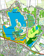
created. In the economically weak region of East Groningen, in the north
of the Netherlands, a public-private partnership is developing an 800-hectare
expanse of agricultural land that has been re-flooded in order to establish
an ideal residential and recreational environment. This project also draws
on the positive identity of water: as a bringer of peace and quiet, an
element that creates space, a recreational lake and a mirror for the architecture.
Now it is the government that is starting to develop an eye for the identity-imbuing
power of water. A body of water is not only the surface, but also has
a bottom. The use of agricultural pesticides over the decades has resulted
in the accumulation of highly polluted sludge at the bottom of expanses
of water and waterways. Intriguing alternatives have been devised for
the expensive process of dredging up and transporting this polluted sludge.
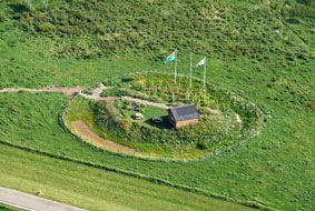
Sealing the dredged-up sludge in containers and using these to raise traditional
‘terps’ (mounds historically constructed to provide a safe
human settlement) in areas prone to flooding would generate identity that
springs from solving a problem.

Experiments in river forelands have also been promoted recently. In the
knowledge that total water management is no longer feasible, the government
has commissioned research into how human settlement and unstable water
levels might be reconciled. The river forelands are the ideal testing
ground for this. Inadvertently, the many luxurious floating villas on
the quiet and stable recreational lakes will then be best prepared for
that prospective instability or deluge. And then their inhabitants can
at last truly put into practice the image of freedom and independence
to which they aspire.
Colophon
Published in: Topos. The International Review of Landscape Architecture
and Urban Design 57 (2006)
Images: Lighthouse dwellings in Barendrecht; icon Amfibisch Wonen (Hans
Venhuizen / Martijn Engelbregt); Amfibisch Wonen First prize: Wetland
- MG Architekten (Tom Mossel, Esther Gonzalez Aurignac); Art Zaaijer,
iinformation centre of IJburg (Amsterdam); Herman Hertzberger, floating
villa in Middelburg; Aquatecture, concept watervilla; De Zwarte Hond,
‘Blue city’, Oost-Groningen; Ministry of Transport, Public
Works and Water management, terps that use sludge out of ditches; Waterstudio,
study after housing in a water-retention area in the Haarlemmermeer.